Imagine you are outside and want to collect as many data as you can get to determine an animal's behaviour. On your sheet of paper you note: weather conditions, temperature, predator activity, spatial distribution, location and any behaviour you observe. To arrange this in a formalized table it would take you many hours! Exactly for these needs I developed the Outdoor Explorer. The Outdoor Explorer will facilitate the recording and analysis of data enourmeously. Some features are listed below.
| 1. Basics
What do you need? First of all you need a handheld computer with a PALM operating system (e.g. Palm IIIx, Palm IIIc, Palm IIIe, Palm V, Palm Vx, Handspring Visor, ...). |
 |
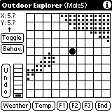
| 2. Map
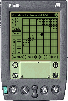
After you have started the Outdoor Explorer you can tap on the screen and record the position in a rough 10x10 grid (e.g. 100 x 100 meters divided into 100 grids of 10 x 10 meters each). On the rough grid you see a map. You can edit your own maps and save them by means of the Preference Screen (see below). |
|
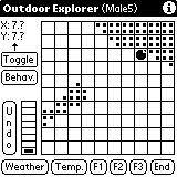
| 3. Position
After you have determined the rough position you can toggle to the Fine Positioning Screen (e.g. 10 x 10 meters divided into 100 grids of 1 x 1 meter each). |
|
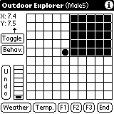
| 4. Toggle
On the Fine Positioning Screen you see a small part of the map. You can enter the exact position of your subject here. If you are working with animals that fly or climb, you can enter the height your focal animal is in, too. |
|
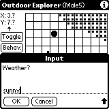
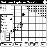
| 5. Weather
You can enter the weather conditions any time. |
|
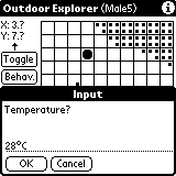
| 6. Temperature
In the same way you can enter the temperature. Additionally, you have 3 undefined fields (F1, F2 and F3) where you can enter any further information you grab. |
|
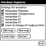
| 7. Preferences
On the Preference Screen you can determine whether the conditional data (weather, temperature, F1 -F3) should be remembered or discarded after the next entry. This is very useful since weather conditions may not change as rapid as for example predator conditions you may have noted in F1. |
 |
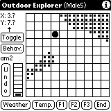
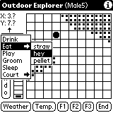
| 8. Behaviour
You can enter up to four letters or numbers to record behavioural observations at any time. Additionally, you can define a list of up to 15 different behaviours with up to 15 modifiers each. You can select from the list by tapping on the 'Behav.'-Button. |
   |
| 9. Data
The data is seperated by semicolon and covers date (20001106=6th of November 2000), time (152345=hh:mm:ss), X-, and Y- position (X3.2= X-position from roughmap and X-position from finemap. By multiplication with a given factor you can calibrate these data to your gridsize), Height (H), weather conditions (W), temperature (T), user defined fields (F1-F3) and your behaviour records (B). |
20001106;152545;X3.2;Y2.5;H0;Wsunny;T34;F1;F2;F3;Bam2 20001106;152842;X3.2;Y2.5;H0;Wsunny;T34;F1;F2;F3;BEat_straw 20001107;112315;X5.1;Y3.5;H0;Wclouds;T34;F1;F2;F3;B 20001107;112545;X5.2;Y3.5;H1;Wclouds;T34;F1;F2;F3;B 20001107;130355;X4.8;Y2.5;H2;Wclouds;T34;F1;F2;F3;B 20001107;152345;X3.2;Y2.5;H3;Wclouds;T34;F1;F2;F3;B 20001108;152345;X7.0;Y8.9;H2;Wsunny;T34;F1;F2;F3;B 20001108;152345;X4.2;Y2.1;H1;Wsunny;T34;F1;F2;F3;B 20001108;152345;X3.8;Y4.5;H0;Wsunny;T34;F1;F2;F3;B |